geo360

20.8.12

Ground Engineering's iPad edition

Ground Engineering is the leading magazine for the UK geotechnics industry providing information on new and practical aspects of geotechnics, engineering geology and geo-environmental engineering.
If you have an iPad, you can now read Ground Engineering magazine for free! GE Magazine is one of the industry's most respected trade publications, affiliated with the UK's New Civil Engineer organization. The app is made available thanks to sponsorship from Allu. I've tried it out, and the format is excellent, the text is easy on the eyes, the figures are out of the way, but accessible with just a tap. Even the advertisements are nice, partially interactive but not over the top. Although they call it an app, it shows up on your bookshelf app.

http://www.geoprac.net/geonews-mainmenu-63/61-available-resources/1208-ground-engineerings-ipad-edition-is-now-live
http://itunes.apple.com/gb/app/ground-engineering-ge/id526030700?mt=8&ls=1 

6.4.12

Rainwater harvesting - Συλλογή βρόχινου νερού

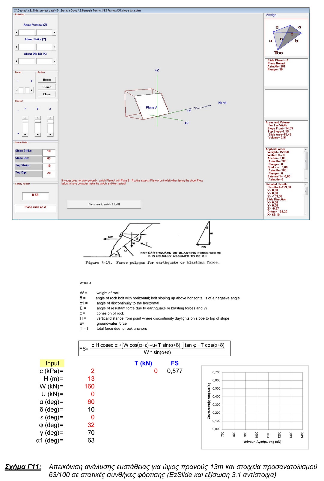
Rainwater collection

Revival of forgotten and traditional techniques in our country which in many cases could be able to provide a small solution for everyday domestic needs. Examples can be drawn by the island of Folegandros (Greece) where rainwater collection program
is implemented.

Συλλογή βρόχινου νερού και νερού ομβρίων στο πλαίσιο της πρακτικής και ορθολογικής διαχείρισης των υδατικών πόρων.
Μεταφορά και αποθήκευση του σε υπόγειες δεξαμενές συλλογής ή/και διήθησης ομβρίων υδάτων με στόχο την επαναχρησιμοποίηση τους αλλά και την διάθεση στο υπέδαφος των πλεονασμάτων.
Αναβίωση ξεχασμένων και παραδοσιακών τεχνικών στη χώρα μας οι οποίες σε πολλές περιπτώσεις είναι σε θέση να δώσουν μικρή έστω λύση για μικρές καθημερινές ανάγκες. Χαρακτηριστικά παραδείγματα στη Φολέγανδρο όπου εδώ και αρκετά χρόνια εφαρμόζεται πρόγραμμα συλλογής βρόχινου νερού για το πότισμα και τη λάτρα του σπιτίου.
 

5.3.12

Pull-out testing for solar panel foundation - Δοκιμές εξόλκευσης πασσάλων θεμελίωσης φωτοβολταϊκών πανελ


Pull-out testing presentation and data interpretation for solar (photovoltaic) panels pile uplift capacity.

In order to determine the pull-out resistance horizontal, vertical as well as lateral load tests are carrying out. 
The first step is to investigate the area where solar panels planned to be constructed with the appropriate site works (geological and geotechnical investigation) for:
  • thickness of top soil layer
  • compaction characteristics
  • sensitivity against weathering and erosion
  • stability parameters in case of sloping ground
  • shear strength parameters (cohesion and friction of bearing soil / rock)
  • allowable bearing pressure (in the case of concrete foundation)
  • bedding modulus
  • ground water
  • soil classification - rock properties
  • tension strength

22.2.12

PLANE FAILURE CALCULATION


Plane failure determination for a 13m high rock slope, using the methodology proposed by US Army Corps of Engineers (Rock Reinforcement EM 1110-1-2907), and by using EzSlide computer software.

Basic Rock Slope Failure Types - Βασικοί Τύποι Αστοχίας Βραχώδους Πρανούς

 Basic Rock Slope Failure Types and their corresponding stereographic projections
 Βασικοί Τύποι Αστοχίας Βραχώδους Πρανούς και οι αντίστοιχες τυπίκες στερεογραφικές προβολές (Τεκτονικά Διαγράμματα)

7.2.12

URETEK ground improvement solutions (Slab lifting, deep injection, powerpile systems)

For over 25 years, URETEK® resin injection techniques have led the world in offering the most advanced and accurate systems for concrete slab lifting and stabilisation. Research and innovation has resulted in the unique URETEK Deep-Injection method of soil stabilisation.

New leading edge technologies are constantly emerging from within the Worldwide URETEK Group. These vary from the application of accurate Hyper-Optic impulse scanning of sub-surface conditions - voids, water, services - to the newly patented URETEK Stitch-in-time, which is a process for restoring, or creating, load transfer across breaks between adjacent sections of concrete pavement slabs.

5.2.12

Waste lanfill slope failure

Waste landfill slope failure in the island of Samos, in an area named "SINKING - ΒΥΘΙΣΜΑΤΑ" !!!! and probably for a good reason.
Unfortunately the appropriate attention did not take place during the geological and geotechnical investigation and design prior the construction of the project (if any).


Landslide Video

31.1.12

Ground penetrating radar being used to detect potential sinkholes and subsurface voids

from: http://www.geoprac.net/

When sewer pipes crack and leak, the surrounding ground becomes saturated and soil can migrate into the pipe and leave behind a void. Eventually this void can expand until it undermines the pavement or other structures forming a sinkhole. The same ground penetrating radar technology being used by geophysicists to perform subsurface characterization and by the military to detect roadside bombs in being adapted to detect these voids before they reach the surface. Researchers at Louisiana Tech University are developing a robot to traverse sewer pipes and scan around the pipe for potential voids using the GPR. The research is being performed with $3M from NIST and $3.2M from Cues, Inc. a Louisiana sewer inspection company. Additional trials are slated to take place this month.
A Cadillac Escalade sits at the bottom of a sinkhole at North and Oakland avenues in Milwaukee on July 24, 2010, after heavy rains caused the pavement to give way. New technology is being tested that can find empty spaces where dirt has seeped into sewers and water pipes before they spread to create huge potholes or sinkholes big enough to swallow a Cadillac. (AP File Photo/Mark Was)
http://dailyreporter.com/2012/01/03/radar-finds-potential-potholes-sinkholes-early/comment-page-1/

5.1.12

World's Largest Landslide - Saidmareh, Iran


Largest Landslide in the World

The Saidmareh Landslide in Iran moved about five cubic miles of material

 
Landsat image of Saidmareh landslide in Saidmareh, Iran. Image composed using data from NASA's GeoCover database. The source area is bounded on the southwest by the crest of the Kabir Kuh anticline. Debris from the slide travelled down the flank of the anticline, across the Karkheh River and continued across the valley floor. Some material in the slide was carried a distance of 14 kilometers (9 miles).

 The largest landslide that has been identified on Earth's surface is the Saidmareh Landslide located in western Iran. The slide occurred about 10,000 years ago when about 20 cubic kilometers (about 5 cubic miles) of Lower Miocene and Eocene limestone detached along bedding planes and slipped down the north flank of the Kabir Kuh anticline. The maximum vertical descent was about 1600 meters (5250 feet).

The sliding slab was about 15 kilometers (9 miles) wide and had a surface area of about 165 kilometers (64 square miles). Debris from the slide crossed the Karkheh River at the base of the slope and spread across the valley floor. Some material in the slide had a travel distance of over 14 kilometers (9 miles).

The slide debris dammed the Karkheh River, causing a large lake to form behind the dam. The lake persisted long enough for up to 150 meters of sediment to accumulate on its bottom (these sediments currently support several thousand acres of cultivated land). The lake then breached the dam and eroded a channel through it.

For more information on the Saidmareh Landslide:

[1] Shoaei, Z. and Ghayoumian, J., 1998, Seimareh landslide, the largest complex slide in the world, In: Moore D. and Hungr O. (editors), Eighth International Congress of the International Association for Engineering Geology and the Environment, Proceedings, Pages 1337-1342.

[2] Harrison, J.V. and Falcon, N.L., 1937,
The Saidmarreh Landslip, Southwest Iran, Journal of Geology, Volume 84, pages 42-47.

[3] Petley, D., 2009,
The biggest landslide of them all - Saidmareh, Iran, Dave's Landslide Blog.